 English
 Japan
Japan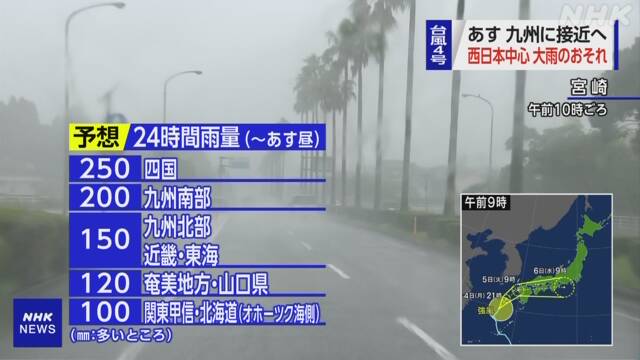 https://www3.nhk.or.jp/news/html/20220704/k10013700941000.html
Typhoon No. 4 is expected to approach Kyushu tomorrow
Atmospheric conditions have become unstable due to effects of
typhoon No.4 and moist air from high pressure, and rain clouds have developed
locally in Kyushu, Shikoku, Kinki, and Hokuriku, which are far from typhoons.
The typhoon is expected to approach Kyushu on July 5th, and
there is a risk of heavy rain, especially in western Japan, and the Japan
Meteorological Agency is calling for caution against sediment-related disasters
and inundation of low land.
According to the observations of the Japan Meteorological
Agency, Typhoon No. 4 is traveling north-northeast at a speed of about 15 km
per hour in the East China Sea at 9 am on July 4th.
The central pressure is 996 hectopascals, the maximum wind
speed near the center is 18 meters, the maximum instantaneous wind speed is 25
meters, and strong winds of 15 meters or more are blowing within 220 km to the
east and 165 km to the west of the center.
In addition to the moist air from Typhoon No. 4, moist air
is flowing around the edge of the Pacific High, causing unstable atmospheric
conditions in a wide range of western and eastern Japan, leaving Kyushu and
other typhoons away. Rain clouds are locally developing in Shikoku, Kinki, and
Hokuriku.
In one hour until 11:00 am
▽
34.5 mm in Toyama City,
▽
Rain gauge installed in Saiki City by Oita Prefecture, 32 mm,
▽
A rain gauge installed in Tanabe City by Wakayama Prefecture is 30 mm. Heavy
rain was observed in both cases.
Due to the rain so far, the risk of sediment-related
disasters has become extremely high in Miyazaki and Toyama prefectures, and
there are areas where “earth and sand disaster warning information” has been announced.
Source: https://www3.nhk.or.jp/news/html/20220704/k10013700941000.html