 English
 Japan
Japan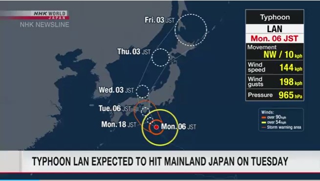 https://www3.nhk.or.jp/nhkworld/en/news/20230814_13/
Typhoon Lan likely to make landfall on Japan's main island
Weather officials are advising residents in the Tokai and Kinki regions to be on the alert for severe downpours. The Japan Meteorological Agency says that as of 9 a.m. on Monday, the strong typhoon was moving northwest off Cape Shionomisaki at 15 kilometers per hour. The storm has a central atmospheric pressure of 965 hectopascals, with winds of up to 144 kilometers per hour near its center and gusts of up to 198 kilometers per hour. Rain clouds near the typhoon are bringing heavy rain to wide areas through the Shikoku to Kanto-Koshin regions.Weather officials forecast thunderstorms for the Pacific coast of eastern and western Japan through Tuesday.
They say bands of rain clouds that may develop over the Tokai and Kinki regions are likely to cause severe downpours on Monday and Tuesday. Strong winds are also forecast for the Tokai and Kinki regions from Monday evening through Tuesday with gusts of up to 126 kilometers per hour. The winds could be strong enough to topple moving trucks.The meteorological agency is warning people to stay on alert for swollen rivers, flooding and mudslides. Airline operators say they decided to ground some flights due to the storm.
Japan Airlines says it canceled 19 flights mainly bound for Osaka airport. All Nippon Airways says it canceled all six flights to and from airports in Tokyo and Hachijojima Island in the Pacific. Central Japan Railway says it canceled Tokaido Shinkansen bullet train services between Nagoya and Shin-Osaka on Tuesday. The railway operator also plans to significantly reduce Shinkansen services between Tokyo and Nagoya.
Source: https://www3.nhk.or.jp/nhkworld/en/news/20230814_13/