 English
 Japan
Japan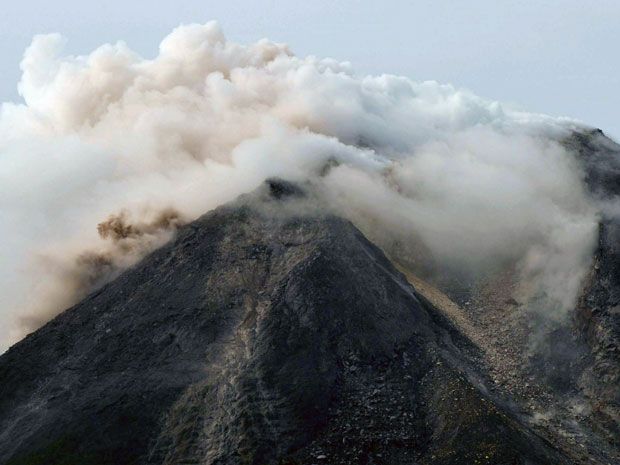 Mount Merapi erupted on Sunday, spewing a 1,000m ash column. (Image via National Post)
Mount Merapi erupts, two villages covered in ashes
On Sunday, Mount Merapi, located on the border between Central Java and Yogyakarta provinces, erupted at 10.46 a.m. local time spewing ashes 1,000m from the crater summit. Mount Merapi Observational Post Kaliurang confirmed the eruption.The Research and Technological Development for Geological Disaster Agency (BPPTKG) in Yogyakarta, the eruption was measured by seismograph reaching a maximum amplitude of 70mm, and it lasted for 155 seconds. Avalanches also occurred for four times with amplitudes of 3 – 8mm and lasted for 18 – 23 seconds.
BPPTKG Yogyakarta set the status of Mount Merapi on “Level II”. In other words, the agency warned the locals and tourists to stay away from the active stratovolcano under a 3km radius.
Volcanology and Geological Hazard Mitigation Center (PVMBG) also warned about the lava flow that might occur following the eruption. While the 1,000m ash column will not disrupt any aviation activities, PVMBG suggested airlines be careful. PVMBG estimated that the ashes will not reach Adi Sucipto Airport because the wind will take it to the west direction.
With the eruption, comes thin ash rain. The ash rain covered two villages: Sumber and Keningar Villages, Magelang Regency. The villages are located 11 – 12km from Mount Merapi. The villagers said that the ash rain lasted for five minutes. Fortunately, the thin ash rain did not affect the locals significantly.
Some tourists on Ketep Hill, located about 6km from Mount Merapi, Magelang Regency, were lucky enough to witness the eruption.
Source: https://bit.ly/2qXROHM


medications neurontin [url=https://neu-ron-tin.com/#]neurontin 300 mg pill [/url] neurontin dosage for peripheral neuropathy what is gabapentin 100mg capsules used for
penile pump implants before after photos taking viagra after a meal side effects viagra and alcohol red viagra tablets best sites for viagra viagra without a doctor prescription walmart viagra dosage and use
plaquenil and acetaminophen how muxh plaquenil per kg how much is plaquenil
neurontin capsules [url=https://neu-ron-tin.com/#]neurontin pills for sale [/url] neurontin 600 mg for irritable bowel how does gabapentin work in the body
generic viagra no prior prescription no ejaculation with tamsulosin natural viagra us pharmacy scam calls generic viagra cvs viagra pills for sale generic viagra can women take sildenafil viagra without a doctor prescription walmart generic viagra dosage recommendations boiled watermelon and lemon juice viagra for women what is viagra professional women s viagra does generic cialis work levitra legal herbal stimulants seeds for favors viagra vs generic viagra reviews sildenafil citrate cost to get fda approved diet supplement powder real viagra without a doctor prescription sildenafil men impotence treatment plavix class action suits updates cute cool pictures viagra prescription drugs nitroglycerin and viagra interaction pfizer generic viagra women enhancement pills over the counter viagra online kaufen best supplements for libido men
hydroxychloroquine azithromycin interaction zithromax tri-pak 500 mg how long does azithromycin last
prednisone interactions average cost of prednisone can you take tylenol while taking prednisone how long do the effects of prednisone last
amoxicillin vs penicillin amoxicilin usa pink bubble gum amoxil flavor how much amoxil to take
neurontin 300mg capsules where can i buy neurontin from canada neurontin for anxiety side effects how much gabapentin to overdose
how long for cialis to work viagra testimonials homemade viagra omeprazole lawsuit for side effects generic viagra from amazon cialis 30 tablet trial
neurontin reviews buy neurontin does neurontin cause the shits how long can you take gabapentin
priligy with phenibut how to get priligy calpers united healthcare priligy where to buy dapoxetine using paypal
ativan and provigil reddit where to buy modafinil how to buy modafinil in us which is more expensive nuvigil or provigil
nuvigil provigil provigil drug buy over the counter drugs like modafinil how to get down from modafinil
best sites for viagra what is similar to xanax cialis 10mg price walmart viagra tablet kroger pharmacy viagra price new weight loss medication belviq
azithromycin in spanish azithromycin 50 mg tablet azithromycin 200mg 5ml dosage children what is azithromycin 250 mg for
ventolin for cough ventolin without a prescription how much ventolin is too much how much are ventolin inhalers
amoxicillin clarithromycin lansoprazole amoxicillin 200 mg tablet taking farmapram and amoxil together amoxicillin 500 mg
best libido herbal supplements for men vaseline samples for healthcare professional viagra without a doctor prescription drinking water after drinking alcohol sildenafil citrate 100mg reviews