 https://www3.nhk.or.jp/nhkworld/en/news/backstories/2559/images/Ltp9RFkGhAnVlxIaASqM31t49hF56fIqIr2rZBFn.png
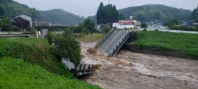
Heavy rain pounds Kyushu
NHK World's meteorologist Tsietsi Monare has more on the record rain that continues in parts of southwestern Japan.The Meteorological Agency says radar analysis shows that about 110 millimeters of torrential rain fell near Uki City, Kumamoto Prefecture, in the hour through 12:00 p.m. Agency officials urge residents to take measures to protect their safety as there is an imminent risk of disaster.
Evacuation orders (as of 11:30 a.m. JST)
Local authorities are issuing evacuation orders for the following areas. The orders are based on the Meteorological Agency's five-level warning scale. The current level is four, which requires residents of dangerous areas to evacuate. Kurume City, Fukuoka Prefecture -Covering 115,809 people -Heightened risk of landslides and flooding along Kurumegawa River Kumamoto City, Kumamoto (9:10 a.m.) -Covering 363,410 people in Chuo, Higashi, Nishi, Minami and Kita wards -Risk of flooding along Shirakawa River Takachiho Town, Miyazaki Prefecture (8:30 a.m.) -Covering all areas of town -Increased risk of disaster Hita City, Oita Prefecture (6 a.m.) -Covering 8,369 people in Amagase, Oyama, Kamitsue, Nakatsue and Maetsue districts Kusu Town, Oita Prefecture (6 a.m.) -Covering 14,220 people Yame City, Fukuoka Prefecture (5 a.m.) -Covering 360 people in Kitayabe District -Heightened risk of landslides Oguni Town, Kumamoto Prefecture (5 a.m.) -Covering 6,502 people -Risk of landslides Mifune Town, Kumamoto Prefecture (3:27 a.m.) -Covering 9,904 people -Risk of flooding Koshi City, Kumamoto Prefecture (12:46 a.m.) -Covering 64,396 people -Risk of landslides Kikuyo Town, Kumamoto Prefecture (1:11 a.m.) -Covering 4,883 people living in landslide disaster caution zone.
Officials have issued landslide alerts for some areas in Fukuoka, Saga, Kumamoto, Oita, Miyazaki and Yamaguchi prefectures.
Kumamoto Prefecture officials say water in the Shirakawa and Mifune rivers has exceeded the flood risk level, as of 10 a.m.
This follows an announcement at 7 a.m. that the Kiyama River in Mashiki Town had overflowed its banks. A still photo captured water flooding roads near the river.
Weather officials say developed rain clouds have been hovering over Kyushu and other areas since Sunday night, bringing the risk of landslides, floods, lightning and tornadoes. The Meteorological Agency issued an extreme rain alert at around 6: 30 a.m. on Monday for Kumamoto Prefecture. But the downpours are now falling mostly in Saga Prefecture, with Takeo City recording 58 millimeters in the hour through 9 a.m. The officials expect the front to remain in the area until tomorrow around noon, bringing more than 50 millimeters of rain per hour to Kyushu and Yamaguchi Prefecture.
Source: https://www3.nhk.or.jp/nhkworld/en/news/backstories/2559/
 English
 Japan
Japan
